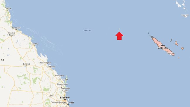
A SOUTH Pacific island identified on Google Earth and world maps does not exist, according to Australian scientists who went searching for the mystery landmass during a geological expedition.
The sizeable phantom island in the Coral Sea is shown as Sandy Island on Google Earth and Google maps and is supposedly midway between Australia and the French-governed New Caledonia.
The Times Atlas of the World appears to identify it as Sable Island. Weather maps used by the Southern Surveyor, an Australian maritime research vessel, also say it exists, according to Dr Maria Seton.
But when the Southern Surveyor, which was tasked with identifying fragments of the Australian continental crust submerged in the Coral Sea, steamed to where the island was supposed to be, it was nowhere to be found.
“We wanted to check it out because the navigation charts on board the ship showed a water depth of 1400 metres (4620 feet) in that area – very deep,” Dr Seton, from the University of Sydney, said after the 25-day voyage.
“It’s on Google Earth and other maps so we went to check and there was no island. We’re really puzzled. It’s quite bizarre.
“How did it find its way onto the maps? We just don’t know, but we plan to follow up and find out.”
News of the invisible island sparked debate on social media, with Twitter user Charlie Loyd pointing out that Sandy Island is also on Yahoo Maps as well as Bing Maps “but it disappears up close”.
On www.abovetopsecret.com, discussions were robust with one poster claiming he had confirmed with the French hydrographic office that it was indeed a phantom island and was supposed to have been removed from charts in 1979.
Another claimed: “Many mapmakers put in deliberate but unobtrusive and non-obvious ‘mistakes’ into their maps so that they can know when somebody steals the map data.”
Google said it always welcomed feedback on a map and “continuously explore(s) ways to integrate new information from our users and authoritative partners into Google Maps”.
“We work with a wide variety of authoritative public and commercial data sources to provide our users with the richest, most up-to-date maps possible,” a Google spokesman said.
“One of the exciting things about maps and geography is that the world is a constantly changing place, and keeping on top of these changes is a never-ending endeavour.”
The Australian Navy’s Hydrographic Service – the department responsible for producing official nautical charts – told Fairfax media it took the world coastline database “with a pinch of salt” since some entries were old or erroneous.
ref: http://www.news.com.au


Leave a Reply
You must be logged in to post a comment.